Earthquake warnings tailored to your organization's needs
Shakewatch
Mobile App
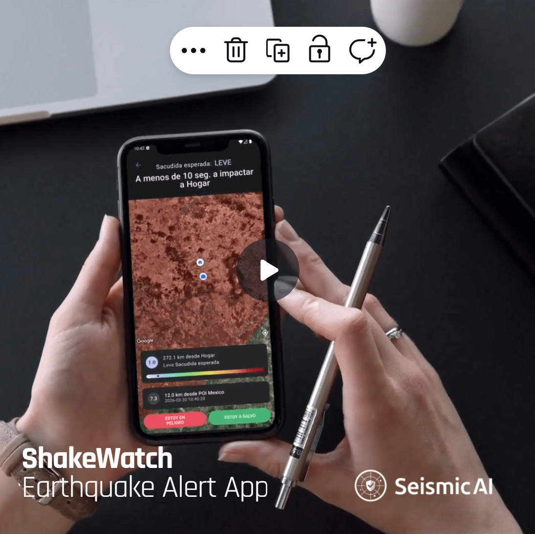
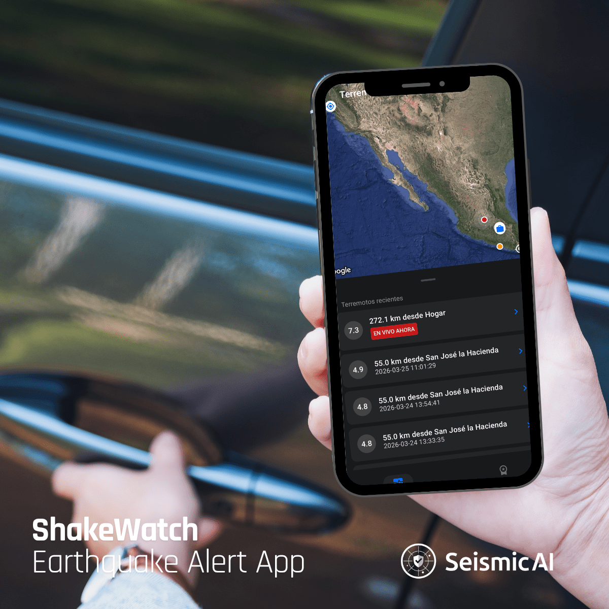
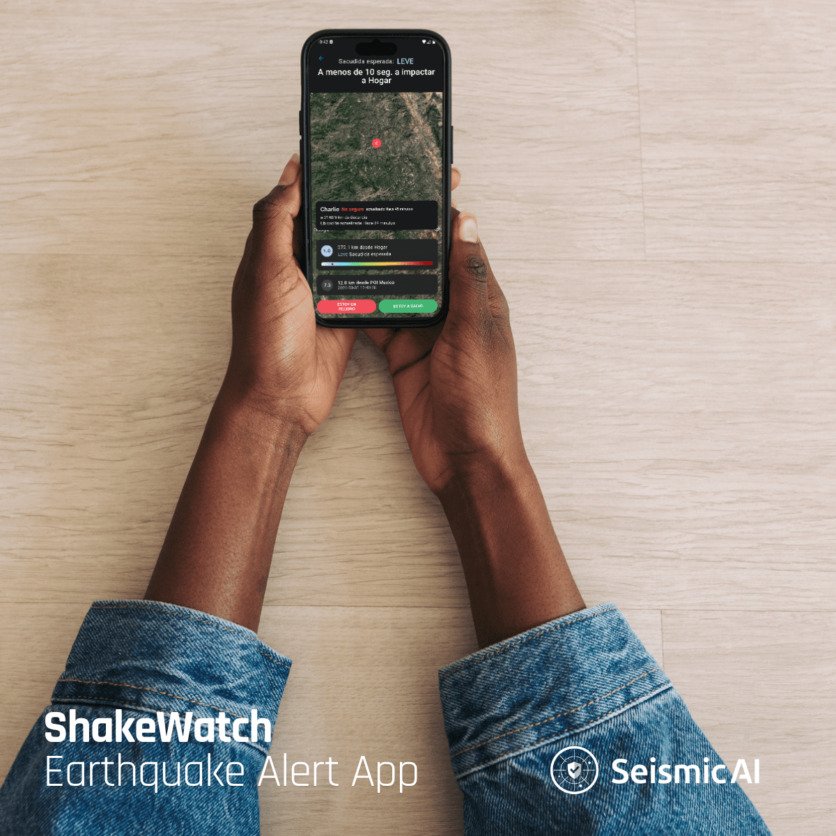
ShakeWatch mobile app is your organization's essential earthquake early warning tool. With real-time alerts, emergency check-ins, countdown to impact, ShakeWatch ensures your facility, operations are team are always prepared. Gain the confidence of knowing your organization is always one step ahead of seismic threats.
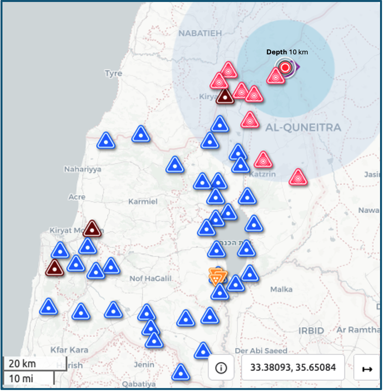
ShakeCommand is a web-based dashboard designed to provide organizations with live earthquake situational awareness and impact assessment. ShakeCommand offers a centralized view of earthquake risks impacting all the organization’s sites—empowering them to make informed decisions. It also provides a log of past earthquakes that have affected your sites.
The ShakeReport Post-Event Report is an automated, data-driven, analytic document designed to help businesses quickly assess the impact of an earthquake. Generated within 30 minutes after an event, the report provides critical insights to support informed decisions on resuming operations safely and quickly.
According to studies, earthquake detection and early warning can reduce non-structural damages from earthquakes by up to 50%, including those caused by fires, chemical leaks and environmental hazards. SeismicAI’s end-to-end innovative SaaS for early earthquake detection and alerting can potentially save billions of dollars for commercial enterprises and government entities.
Our Array technology generates fast earthquake alerts, maximizing business continuity by reducing damages to facilities, teams and finances.
High Precision
Our EEW solution reduces false positives and misses, and informs on precise location and magnitude. This prevents unnecessary halts and shutdowns.
Plug & Play
Our global seismological algorithms are operational in days. They easily incorporate multiple data sources, from standard seismic sensors or proprietary array technology.
Continuous Performance Indication
Our earthquake early warning system (EEW) uses mild events to train and optimize its functionality and ensure top performance.
The only company worldwide insured by a reinsurance company, with compensation for false or missed alerts.
Cost-Effective
Our seismic alert solutions are easily accessible to business and public entities of all sizes
Customized to Your Needs
Tailoring earthquake alert levels, thresholds and triggers to the organization’s requirements
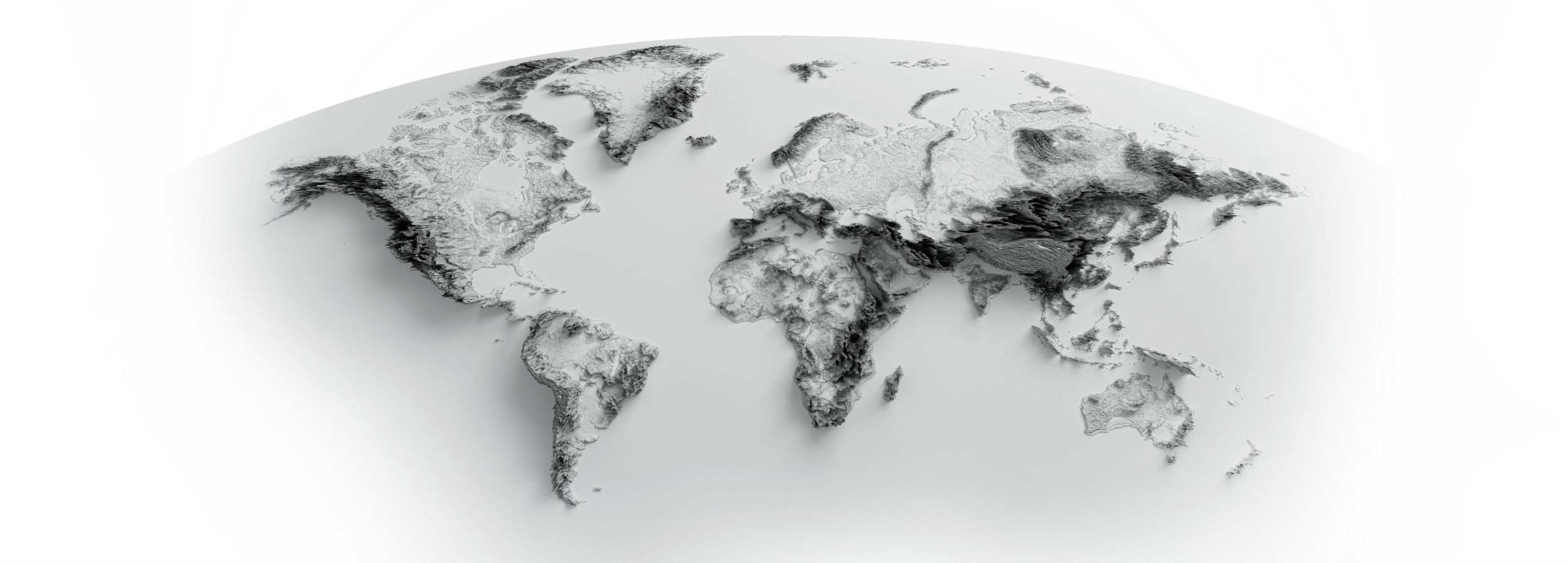
PROVEN WORLDWIDE
SeismicAI earthquake detection & alert systems are successfully deployed in North and Central America, Europe and Asia.
Our technology is integrated into national systems, in collaboration with a variety of research institutes, civil organizations, and governments worldwide.
SeismicAI earthquake detection and alert technology is based on array seismology, which maximizes information extraction from waveforms, optimizing the precision of predictions with less data. Our earthquake early alert system is based on over a decade of research at Tel Aviv University, and researches published in world-leading journals.
We use cookies on our website to give you the most relevant experience by remembering your preferences and repeat visits. By clicking “Accept All”, you consent to the use of ALL the cookies. However, you may visit "Cookie Settings" to provide a controlled consent.
This website uses cookies to improve your experience while you navigate through the website. Out of these, the cookies that are categorized as necessary are stored on your browser as they are essential for the working of basic functionalities of the website. We also use third-party cookies that help us analyze and understand how you use this website. These cookies will be stored in your browser only with your consent. You also have the option to opt-out of these cookies. But opting out of some of these cookies may affect your browsing experience.
Necessary cookies are absolutely essential for the website to function properly. These cookies ensure basic functionalities and security features of the website, anonymously.
Cookie
Duration
Description
cookielawinfo-checkbox-advertisement
1 year
Set by the GDPR Cookie Consent plugin, this cookie is used to record the user consent for the cookies in the "Advertisement" category .
cookielawinfo-checkbox-analytics
11 months
This cookie is set by GDPR Cookie Consent plugin. The cookie is used to store the user consent for the cookies in the category "Analytics".
cookielawinfo-checkbox-functional
11 months
The cookie is set by GDPR cookie consent to record the user consent for the cookies in the category "Functional".
cookielawinfo-checkbox-necessary
11 months
This cookie is set by GDPR Cookie Consent plugin. The cookies is used to store the user consent for the cookies in the category "Necessary".
cookielawinfo-checkbox-others
11 months
This cookie is set by GDPR Cookie Consent plugin. The cookie is used to store the user consent for the cookies in the category "Other.
cookielawinfo-checkbox-performance
11 months
This cookie is set by GDPR Cookie Consent plugin. The cookie is used to store the user consent for the cookies in the category "Performance".
elementor
never
This cookie is used by the website's WordPress theme. It allows the website owner to implement or change the website's content in real-time.
viewed_cookie_policy
11 months
The cookie is set by the GDPR Cookie Consent plugin and is used to store whether or not user has consented to the use of cookies. It does not store any personal data.
Functional cookies help to perform certain functionalities like sharing the content of the website on social media platforms, collect feedbacks, and other third-party features.
Performance cookies are used to understand and analyze the key performance indexes of the website which helps in delivering a better user experience for the visitors.
Analytical cookies are used to understand how visitors interact with the website. These cookies help provide information on metrics the number of visitors, bounce rate, traffic source, etc.
Cookie
Duration
Description
_ga
2 years
The _ga cookie, installed by Google Analytics, calculates visitor, session and campaign data and also keeps track of site usage for the site's analytics report. The cookie stores information anonymously and assigns a randomly generated number to recognize unique visitors.
_ga_FMPZCLWCH4
2 years
This cookie is installed by Google Analytics.
CONSENT
2 years
YouTube sets this cookie via embedded youtube-videos and registers anonymous statistical data.
Advertisement cookies are used to provide visitors with relevant ads and marketing campaigns. These cookies track visitors across websites and collect information to provide customized ads.
Cookie
Duration
Description
_rdt_uuid
3 months
Reddit sets this cookie to build a profile of your interests and show you relevant ads.
muc_ads
2 years
Twitter sets this cookie to integrate and share features for social media and also store information about how the user uses the website, for tracking and targeting.
personalization_id
2 years
Twitter sets this cookie to integrate and share features for social media and also store information about how the user uses the website, for tracking and targeting.
VISITOR_INFO1_LIVE
5 months 27 days
A cookie set by YouTube to measure bandwidth that determines whether the user gets the new or old player interface.
YSC
session
YSC cookie is set by Youtube and is used to track the views of embedded videos on Youtube pages.
yt-remote-connected-devices
never
YouTube sets this cookie to store the video preferences of the user using embedded YouTube video.
yt-remote-device-id
never
YouTube sets this cookie to store the video preferences of the user using embedded YouTube video.